
Dangers of flying in Uncontrolled Airspace: Safety Tips
The belief that traditional aircraft won’t be flying below 400 feet is a common misconception among drone pilots. Except for takeoff and landing, most fixed-wing aircraft typically operate above 400 feet, but this is not the case with helicopters and agricultural aircraft. Some aircraft, including helicopters and agricultural aircraft, often fly below 400 feet and routinely share the same airspace as drones.
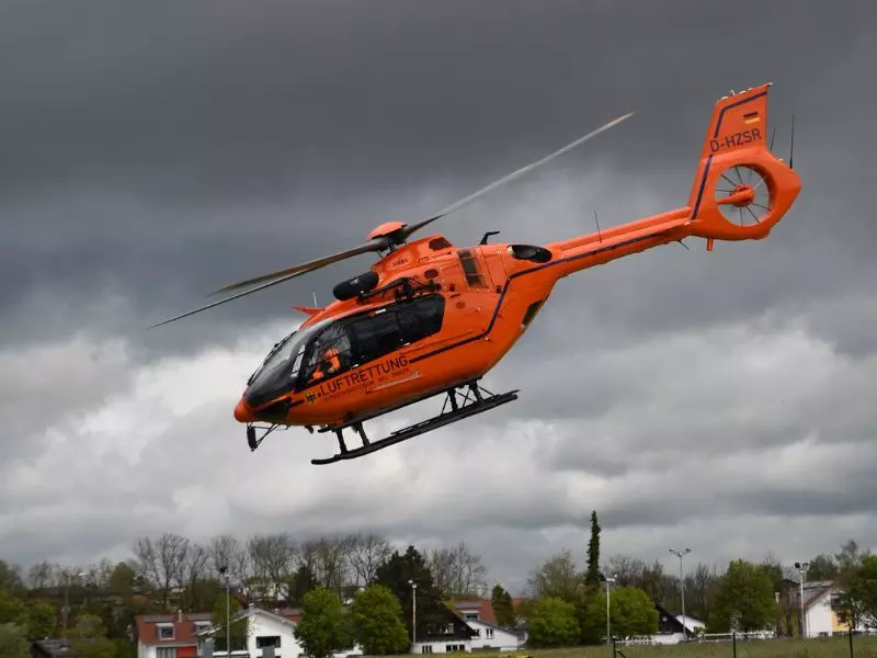
Helicopters are supremely susceptible to catastrophic damage in the result of a drone striking any part of the helicopter, most notably the windscreen and rotors. Helicopters, more than any other aircraft type, fly over dense urban areas where margin for error is small. A large number of helicopter missions fly to areas where there is likely to be an increase in drone activity.
FAA Rules That Apply
Part 107 requires a drone pilot to perform an assessment of the operating environment prior to flight. This assessment must consider risks to persons and property in the immediate vicinity, both on the surface and in the air. The assessment assists the remote pilot in selecting a location that ensures adequate visibility of the surrounding airspace at all times during the flight. Adequate visibility of the surrounding airspace provides remote pilots with the opportunity to deconflict from other aviation traffic as required by 14 CFR section 107.37.
-
The remote pilot must choose a location which will not prevent them from seeing or hearing the helicopter until it’s too late to maneuver out of the way.
-
The remote pilot should use a visual observer to assist in scanning the surrounding airspace for other aviation traffic.
-
The remote pilot can’t just focus on viewing the controller display during the operation.
-
Remote pilots are encouraged to use anti-collision lights during daylight operations. The use of anti-collision lights can aid other pilots in identifying drones.
Proper Drone Piloting
As required by regulation, remote pilots must assess the operating environment prior to flight. This assessment must consider the risk to other aircraft in the vicinity of the planned operation. Remote pilots planning flights in urban areas are encouraged to include helipad locations in their preflight planning assessment. Specifically, they should consider the direction and distance of helipads in relation to the operational area of their flight. Remote pilots are reminded that helicopters arriving or departing from helipads routinely operate at low altitudes and speeds in excess of 130 mph.
Identifying the direction and distance of helipads can assist the remote pilot in selecting the best location for the ground control station. This information can assist the remote pilot in selecting the appropriate number and physical location of visual observers needed for the operation.
Any effective mitigation strategy for collision avoidance depends upon an understanding of the visual line of sight (VLOS) concept. Visual line of sight aircraft operation is defined in 14 CFR section 107.31 and requires both the ability to see the drone at any time and observe the airspace for other aircraft. Section 107.37 requires the remote pilot to yield the right of way to all aircraft and not create a collision hazard.
On average it takes 12.5 seconds for an undistracted pilot to react to another aircraft. A helicopter traveling at 115 mph covers a half mile in 12.5 seconds. Remote pilots and visual observers are encouraged to ensure they can scan the surrounding airspace to at least half a mile in all directions. Additionally, the view of the surrounding airspace should extend down to the horizon and be free of obstacles or obstructions. If unable, remote pilots should incorporate additional mitigations to their planned operations to ensure an acceptable level of safety.
Our Mission: Take Aerial photographs of a property located 1.5 miles from a Class G Municipal Airport
While airport traffic and landing pattern information isn’t something most Part 107 UAS pilots may be familiar with, it’s important to understand this information specific to the small airport you will be operating near prior to beginning your operations. When working at a location near a busy small airport, we use Apps such as airnav.com to familiarize us with the airport’s traffic patterns and other useful information that can help us fly a safe mission.
Also, prior to starting the mission, our Pilot in Charge (PIC) will make a courtesy call to the local municipal airport to alert them of the location we will be flying at, our altitude, and our start and stop times. This is not required when flying in uncontrolled airspace, but we make it our rule to do this as an additional safety measure, and it is always appreciated by the local Class G airports.
A quick, informative call such as “Remote Pilot Jorda – at (address) – flying a max of 400 ft – 9am-10am”…this informs the tower of our presence for incoming/outgoing traffic, and it informs us of any operations that the tower feels could interfere with our mission. This quick call can make a big difference in the safety of our mission, and we love hearing “You should have no issues today, we appreciate the call, have a safe flight”.
Drone and Helicopter Close Encounter
Recently Web-tactics was hired to take aerial photographs of a property located a mile from a local Class G municipal airport, in uncontrolled airspace. While operating their drone at 170 feet during their mission, a low flying helicopter entered the area, approaching for landing at the airport. As required by Part 107, the Pilot in Charge (PIC) yielded the right of way to the manned aircraft, and immediately changed their position and altitude to safely avoid the manned aircraft’s flight path.